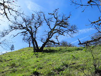
 Peering downhill and ignoring the "Danger: No Access Beyond This Point" sign, we determined we could struggle to the beach along the badly damaged trail. After all, so many others had preceded us. What could possible happen? Famous last question. Wide gaps in the previously smooth slope gaped before us. Rocks and roots angled unnaturally having been rent from the main landscape. Tall fir trees angled sideways as if attempting to keep their balance while sliding downhill. Steps carved in the damp sandy soil provided huge treads on the lower grade with an upturned milk carton box serving as the final connection to the beach. Looking back up the trail we wondered whatever possessed us to make this descent!
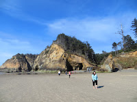
Surviving that danger we strolled south along the coastal trail of wide beige sand uncluttered by ocean debris. On a previous hike the beaches here were coated with blue jellyfish that had been blown ashore. But today it was just people, dogs and surfers enjoying the warm onshore breezes. Hard packed sand divided by the occasional runoff stream served to make the miles go by quickly. Ahead was Hug Point, an outcrop of rock that once served as part of the coastal transportation route prior to the development of Highway 101. Pick axes and dynamite carved out a rough one-way path for horse carts and later the first automobiles to travel between small coastal towns in the 1800's. If you time it right with the tide table you can still walk along this section and see the wheel and tire ruts, now barnacle encrusted, and traverse the rocky point to arrive at Hug Point beach and another State Park.
Here the beach dips into natural caves, dark, chilly and clogged with great logs floated in by extremely high tides that firmly lodged them behind interior rocks. Water drips through the layers of interesting rock structures. Read about them here. Hikers can explore these shallow caverns but do keep an eye on the incoming tides. They fill the caves quickly at times and can pose a danger to those caught unawares. Farther south there is a waterfall that cascades over the boulders restraining a part of the hillside.
Technically you can hike the fourteen miles from Cannon Beach south to Manzanita, hooking up with the Oregon Coast Trail at Arch Cape, rounding the point at Cape Falcon and Short Sands Beach, formerly Smugglers' Cove and then finishing at Manzanita. That's a long day! Best to have a car waiting at the end. If that little jaunt is a no-go then pick a portion of the trail and enjoy the sample.
Wondering if we should exit the beach at Hug Point State Park and walk the narrow, winding highway back to Arcadia State Park, a glimpse of the whizzing cars made that an easy decision. We decided to take our chances with the tide and the landslide. Crossing the little streams that widen as they join the breakers we timed our arrival at Hug Point just as the tide turned to flow in. Watching the wave action as it splashed at the base of the rocks we waited until there was one of those pauses when the sand is visible and jumped up to the first shelf of barnacles and seaweed-covered rock. Turning back for a moment to view the seascape prompted a plea to another hiker to snap our human portrait against the vast ocean shoreline. As the waves crashed higher and higher against the western border we followed those aged wheel ruts around the Point and carefully avoided the slippery, wet seaweed waiting in the shadows for breakers to flood it once again.
 Touching down on solid sand we ambled along the high water line, noting various sights and enjoying the clear and windless afternoon. Searching for an alternate route to the parking area we found nothing suitable so scrambled from milk carton box to sandy steps, now beginning to crumble under frequent foot traffic, jumping over crevices and uprooted trees and arrived, against descending beach goers, to the safety of the level park. I guess warning signs are for naught if so many of us ignored them. We were lucky today. Perhaps not so much another time. But as the Bard wrote "all's well that ends well". So we live to hike another day!
 |
| Largest of the caves - it goes way back |
 |
| Wheel ruts in the rocks |
 |
| Slippery, green seaweed awaiting the tide |
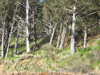 |
| Trees lean to balance on the slipping slope |
 |
| Sandy, crumbling steps |
 |
| Sliding slope |
 |
| Jump! |

