April wildflowers. Sunny side of the Gorge. Low winds. Moderate temps. Clear sky. Sounds like a perfect hike scenario. Heading east out of an overcast Gresham we made for the Hood River bridge as our crossing point into Washington. As expected, once we passed "the line" just west of Hood River the weather cleared and we entered the magical middle Gorge. Today's hike was a new one for most of the hikers and they were anxious to see the trail's offerings. There was no disappointment on this trek.
Missing the tiny gravel parking lot immediately east of the two tunnels past Lyle, our driver maneuvered the car in a safe u-turn and pulled off Highway 14 at the trailhead. There is no signage here so it's a tricky spot to locate. Having been warned about the ticks and poison oak, we sprayed our clothing and tucked in our pant legs to ensure a healthy hike.
We began with a series of moderate switchbacks through open stands of Garry oak and across several patches of scree. At the quarter mile mark the trail sign appeared as well as a sign-in form. This trail belongs to the Friends of the Gorge Land Trust so is technically private with liability and permission-to-use issues. From this point the trail continues its constant uphill route, switchbacking through more of the same terrain and across three greater rockslides until it breaks out at the first viewpoint at the bench or smooth, relatively level flatland on one of the rock layers.
From the very start of the trail glossy burgundy leaves of
poison oak, loaded with their urushial oil, were just itching to touch us. It lined the trail in many places, even appearing in the middle of it. Patches of it nestled under the oaks and once we made the grassy hilltop it exploded in an exponential display of color and hazard. Not content to remain exclusive in its growth, poison oak enjoys blending with the local wildflowers as if trying to add a deep background color to natural bouquets. Just when you reach out to examine a lovely flower you jerk back in an aversive move to avoid brushing against a shiny leaf.
As if in battled contrast there were swaths of
western wild cucumber vines in full bloom, fragrant white flowers drawing all kinds of colorful flying insects to their green patches. Tiny spiky fruit was already forming on vines that can reach nine feet or more. The hillside scene was reminiscent of
pointillism, the art of painting in dots which form a detailed picture at a distance.
Wildflowers in white, yellow, pink blue and purple intermixed with the greens and beige of the grasses to sketch a colorful foreground for the sweeping views of the Gorge beyond.
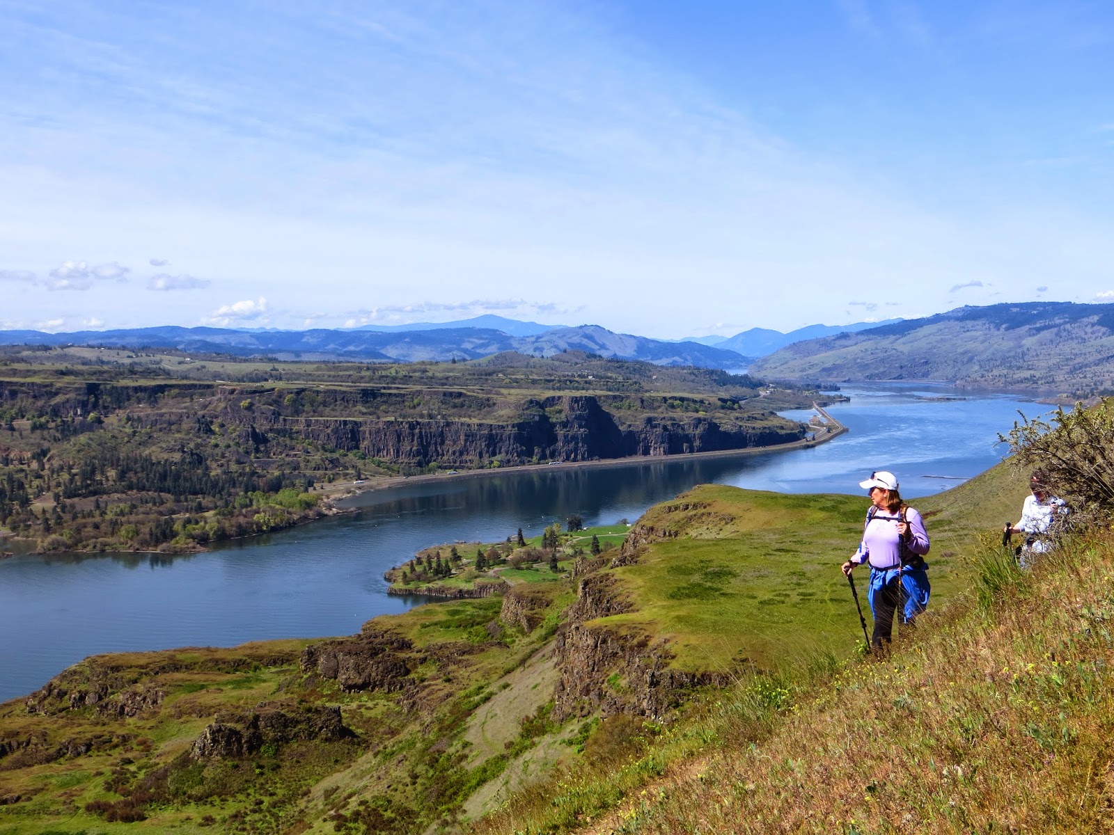
Aside from the springtime wildflower displays, it is the views of the mighty Columbia River that make this hike worthwhile. Rising to the top of the layer cake-like
rock formations we stopped frequently to gaze at the immense volume of water traveling westward, curving around the
big bend at The Dalles and heading toward Portland and the Pacific Ocean beyond there. Each curve in the trail took us higher and higher until we reached 1160 feet above the river, the view expanding all the way. Once there we began to curve north around the ravines of the rock formations that line the Gorge. The oak forest here was grey and scruffy, ancient in its leafless limbs and decaying ancestry. The trail wound back and forth, up and down until we reached The Orchard on an outcropping of open field. The orchard site is barely evident except for a few dead stumps and a strange cross marking perhaps a burial site. Nonetheless you can imagine a homestead life here a hundred years ago, rough and unforgiving but rewarded each day with a dramatic view.

Lunching against an artistically posed dead tree we inhaled the fresh, warm air and soaked up the expansive views before returning to the trail. Easier in many respects going downhill, the trek was still challenging at steep points where rocks and dry soil promoted slipping and sliding. The views on this leg were constantly before us and distracting to safe footing. Watch your feet, not the view I told myself numerous times. Unwilling to hurry down we took a side trail at the bench formation to peek over the cliffs. The town of Lyle and its boat landing were just below us to the west. Tugboats pushed barges up and down the river with smooth efficiency leaving quiet spreading wakes behind them. Falcons soared in the thermals rising from the cliffs and any rattlesnakes that may have been present had the decency to hide themselves from us. Ticks were rebuffed by insect repellent but Steel, our trail dog, picked up a few little newborns that his owner quickly dispatched.

Facing south, this side of the Gorge heats up quickly in the spring sun so bring lots of extra water, slather on sunscreen and bring trekking poles for stability. The five mile in and out trail took about three hours but we weren't in a rush, taking time to eat, drink and appreciate the scenery. Intrigued by a news article highlighting the restoration of the historic
Lyle Hotel we stopped by for a look. It is indeed a quaint local business, rustic on the outside but restored on the inside. A new covered patio offers cool dining opportunities and a handyman just happened to be there to answer our questions and let us peek inside. Take a day to explore the large and small grandeur of the magical middle Gorge while the temperatures are moderate and the floral display is at its best. You won't be disappointed!
 |
| Trailhead starts up fast! |
 |
| typical rock formation |
 |
| innocent-looking poison oak |
 |
| lower portion of the trail on steep hillside |
 |
| purple lupine |
 |
| the shadow under tree is ALL poison oak! |
 |
| tri-colored Cluster lily (Triteleia) |
 |
| Death camas |
 |
| wild cucumber |
 |
| Desert parsley (Lomatium) |
 |
| still climbing |
 |
| view from the bench area |
 |
| Balsamroot |
 |
| Balsamroot blossom |
 |
| hillside "pointillism" |
 |
| arriving at The Orchard ara |
 |
| lupine with The Dalles in background |
 |
| Steel taking a break |
 |
| today's happy hikers |
 |
| old grave marker out of place |
 |
| view east |
 |
| heading back |
 |
| Chocolate or checkered lily (Fritillaria) |
 |
| the sometimes pond area, dry today |
 |
| trail up top through oak forest |
 |
| shiny poison oak |
 |
| tiny points of color |
 |
| fence stile and view to west |
 |
| no need to hurry here! |
 |
| The Bench area |
 |
| frequent viewing pauses |
 |
| heading downhill |
 |
| hikers blend with scenery |
 |
| nature's bouquet |
 |
| poison oak mingling with desert parsley |
 |
| Lyle Hotel restaurant interior |
 |
| Dining room |
 |
| Living room |
 |
| Hotel lobby |
 |
| Rustic exterior |
 |
| newly built patio |
 |
| small bar area with restored bar front |
 |
| layer cake rock formation |